1st Hand / Data Backed Updates on Red Tide Spread

This section is for our members to talk about things not actually about fishing or boating. However, please read the Code of Conduct before posting.
Image

Moderators: bman, Chalk, Tom Keels

Post Reply
User avatar
big bend gyrene
Moderator
Posts: 2457
Joined: August 8th, 2005, 9:30 am
Location: Monticello, FL

1st Hand / Data Backed Updates on Red Tide Spread

Post by big bend gyrene »

Versus following other threads with folks questioning where the red tide has spread, opening this post FOR ACTUAL FIRSTHAND location reports from those on the board OR shares that can be followed / substantiated (i.e. satellite image updates from FWC, etc.)

Simple as that... hard information sharing that will be useful to others. Please DON'T use this thread for anything else or I'll do my best to get Bman to remove them... not the thread to question causes, argue over impacts to polar bears, or attack / defend Famous Jameis. Please also avoid sharing, "Heard from a friend of a friend's friend" updates.

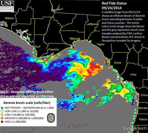
In the interest of sharing hard information, here's the last satellite image FWC posted on 9/19/14. Using Google Earth, looks like we very likely are having some fish killed about 18 miles southeast of St. Marks / 15 miles or so southwest of Econfina. Here's hoping it doesn't spread much more before it's over and that this thread ends up being blessedly absent many additional updates.
salute1
BloomArea091914.jpg
BloomArea091914.jpg (133.94 KiB) Viewed 3411 times
"The Marines I have seen around the world have the cleanest bodies, the filthiest minds, the highest morale, and the lowest morals of any group of animals I have ever seen. Thank GOD for the United States Marine Corps." Eleanor Roosevelt, 1945
User avatar
red_yakker
Site Sponsor
Posts: 776
Joined: May 26th, 2009, 3:19 pm

Re: 1st Hand / Data Backed Updates on Red Tide Spread

Post by red_yakker »

My wife's husband's uncle's nephew says that the water should start cooling off pretty soon and this whole red tide fiasco will be but a memory.
Now, if only we can get Congress to....... Just Kidding ;)
The gods do not deduct from man's allotted span the hours spent in fishing. ~Babylonian Proverb
Salty Gator
Site Sponsor
Posts: 3437
Joined: April 17th, 2010, 7:23 pm
Location: Tallahassee

Re: 1st Hand / Data Backed Updates on Red Tide Spread

Post by Salty Gator »

red_yakker wrote:My wife's husband's uncle's nephew says that the water should start cooling off pretty soon and this whole red tide fiasco will be but a memory.
Now, if only we can get Congress to....... Just Kidding ;)
:thumbup: :smt005
Catholic girl pray for me, you’re my only hope for heaven
User avatar
MudDucker
Site Sponsor
Posts: 6664
Joined: June 22nd, 2005, 3:07 pm
Location: Valdosta, Georgia

Re: 1st Hand / Data Backed Updates on Red Tide Spread

Post by MudDucker »

There are polar bears in the bigbend area? :o
Its a wonderful day in the neighborhood!
Blue spinner
Site Sponsor
Posts: 1941
Joined: May 23rd, 2011, 8:26 am
Location: Pelham Ga./Econfina

Re: 1st Hand / Data Backed Updates on Red Tide Spread

Post by Blue spinner »

Thanks BBG for the information
One thing about the speed of light it gets here too early in the morning
FUTCHCAIRO
Posts: 6065
Joined: December 26th, 2004, 2:36 pm
Location: CAIRO,GA

Re: 1st Hand / Data Backed Updates on Red Tide Spread

Post by FUTCHCAIRO »

THANKS JARHEAD, GOOD TO KNOW ALTHOUGH I WILL NOT BE ABLE TO GO FISH ANYWHERE TIL THIS HIP HEALS UP A LOT MORE, DOC SAID ABOUT 3-4 MORE WEEKS AND I SHOULD BE LIKE NEW.
PA
SEMPER FI
FUTCHCAIRO
User avatar
wevans
Site Sponsor
Posts: 12827
Joined: June 12th, 2002, 11:06 am
Location: Sopchoppy

Re: 1st Hand / Data Backed Updates on Red Tide Spread

Post by wevans »

Forecasts by the USF-FWC Collaboration for Prediction of Red Tides for the next three days show strong offshore movement of surface waters and slow onshore movement of bottom waters for the bloom patch located at the coast near Levy County. The patch located south between Wakulla and Taylor counties and ESE of Franklin County is predicted to continue to move west. Offshore of Pasco and Hernando Counties, the surface patch is predicted to move NW, and bottom waters are predicted to move NE along the coast.
:thumbup: :thumbup: :beer: :beer:
“Before you criticize someone, you should walk a mile in their shoes. That way when you criticize them, you are a mile away from them and you have their shoes.”
Image
Danibeth
Posts: 367
Joined: February 25th, 2014, 9:58 pm

Re: 1st Hand / Data Backed Updates on Red Tide Spread

Post by Danibeth »

Today's map

Image
User avatar
big bend gyrene
Moderator
Posts: 2457
Joined: August 8th, 2005, 9:30 am
Location: Monticello, FL

Re: 1st Hand / Data Backed Updates on Red Tide Spread

Post by big bend gyrene »

Danibeth, many thanks for the updated map.
"The Marines I have seen around the world have the cleanest bodies, the filthiest minds, the highest morale, and the lowest morals of any group of animals I have ever seen. Thank GOD for the United States Marine Corps." Eleanor Roosevelt, 1945
User avatar
zload
Site Sponsor
Posts: 749
Joined: September 8th, 2011, 12:57 pm

Re: 1st Hand / Data Backed Updates on Red Tide Spread

Post by zload »

If you are interested or if things start to go badly, you can go to the source page where the FWC map is posted Red Tide Status scroll down a little below the static map and you will see a link for a Google Earth map, link title is listed as current Statewide Google Earth map for September 19, 2014., it allows for scrolling, zoom, point to point distance and it lets you click on the sample flags to get location specific sample details. Appears that the Google Earth data is not being updated until the Friday after the midweek update.

The medium flag showing up on the 09/19 Google map, not far from Pepperfish Keys is about 4.5 miles off the grass line and according to the new static map that area is sampling much higher now than last week.
2008 Key West 196 Bay Reef
2008 Yamaha 150
User avatar
big bend gyrene
Moderator
Posts: 2457
Joined: August 8th, 2005, 9:30 am
Location: Monticello, FL

Re: 1st Hand / Data Backed Updates on Red Tide Spread

Post by big bend gyrene »

Sure wish the satellite images weren't so obscured by cloud cover. Looks to me like there's a good bit more red indeed offshore of the Dixie/Taylor line, as well as westward movement as predicted earlier by FWC. Just hard to see if much northern movement occurred towards our nearshore waters because of the cloud cover / gray on the map. Maybe we'll find out with the next image post. Meantime, anybody actually running offshore who finds evidence of the bloom, please share here.
"The Marines I have seen around the world have the cleanest bodies, the filthiest minds, the highest morale, and the lowest morals of any group of animals I have ever seen. Thank GOD for the United States Marine Corps." Eleanor Roosevelt, 1945
User avatar
big bend gyrene
Moderator
Posts: 2457
Joined: August 8th, 2005, 9:30 am
Location: Monticello, FL

Re: 1st Hand / Data Backed Updates on Red Tide Spread

Post by big bend gyrene »

Red Tide Status Reports (September 26, 2014) per http://myfwc.com/research/redtide/statewide/

Surface bloom starting approximately 5 to 35 miles offshore, dependent on location, between Franklin and Citrus counties, and less than 3 miles offshore of Cedar Key (Levy County). Concentrations of the red tide organism in these areas range from background to high.

Fish kills were reported last week off Rocky Creek Channel (Taylor County), Horseshoe Beach (Dixie County), and approximately 9-12 miles offshore of Keaton Beach (Taylor County), as well as offshore in the bloom area. No respiratory irritation has been reported alongshore the west coast of Florida; however, respiratory irritation is possible in the bloom areas.
"The Marines I have seen around the world have the cleanest bodies, the filthiest minds, the highest morale, and the lowest morals of any group of animals I have ever seen. Thank GOD for the United States Marine Corps." Eleanor Roosevelt, 1945
User avatar
fishinfool
Site Sponsor
Posts: 3094
Joined: June 17th, 2009, 8:58 pm

Re: 1st Hand / Data Backed Updates on Red Tide Spread

Post by fishinfool »

Updated map.....
BloomArea0926FORWEB_597x468.jpg
BloomArea0926FORWEB_597x468.jpg (89.83 KiB) Viewed 2839 times


It is a little too close for my comfort.
User avatar
fishinfool
Site Sponsor
Posts: 3094
Joined: June 17th, 2009, 8:58 pm

Re: 1st Hand / Data Backed Updates on Red Tide Spread

Post by fishinfool »

I was out Wednesday 10-1-14. I fished from the Lighthouse to just past Palmetto Island and out to Grey Mare rock. I did not see any evidence of red tide or dead fish.
User avatar
big bend gyrene
Moderator
Posts: 2457
Joined: August 8th, 2005, 9:30 am
Location: Monticello, FL

Re: 1st Hand / Data Backed Updates on Red Tide Spread

Post by big bend gyrene »

Latest map. Thankfully this one has less cloud cover so can see a bit more what's going on closer to shore in our area. On a positive note, looks like a good bit of the red that was approaching us offshore off of Dixie county has quieted down (compare to 9/26 map) apparently shifting further westward (not so positive for those who fish way offshore out of Carrabelle / St. George Island). Got excited when I first saw the map but then did notice that there is a thin band of low concentrations inshore off of the northern portion of Taylory county's coast, with spots of even higher levels possibly evident (looks like a few orange and red blips). Fingers AND toes crossed that it keeps calming down in general so that our area can dodge the bullet.

Anyone fishing out of Fenhollway, Econfina, or Aucilla this weekend sure be appreciated if reports are shared be they good news or bad.
bloomarea100314_600x515.jpg
bloomarea100314_600x515.jpg (106.85 KiB) Viewed 2671 times
"The Marines I have seen around the world have the cleanest bodies, the filthiest minds, the highest morale, and the lowest morals of any group of animals I have ever seen. Thank GOD for the United States Marine Corps." Eleanor Roosevelt, 1945
Post Reply