5/11 St Marks flats
Posted: May 12th, 2019, 11:40 am
Tried to go offshore around 6:30am out of St Marks but wind was worse than forecasted and as soon as we got beyond the Birdrack the rollers were 3-4ft with a short period. Too much to risk running all the way out to the reefs and it getting any worse in my boat. We trolled the surface a bit back towards the east flats hoping it would calm down but wind stayed up for the next few hours.
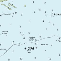
I've only ever been on the east flats in other peoples' boats or in kayaks so I wanted to take it real slow and map the area with the sidescan. We slow trolled and drifted all the way to the Rock Garden and spent a few hours recording sonar logs of the rocks. There were lots of pinfish in the grass out at the garden but we found very few between there and the Lighthouse. We did bump a rock going about 2kts but doesn't seem to have done any damage. Boated one 22 inch trout and lost a couple of other nice ones with swimbaits and Gulp shrimp on jigheads, plus a number of shorts. Also caught a 4 foot spinner shark on a pinfish under a float, a small flounder, handful of small BSB and a decent spanish mack on a tree rig close to the Long Bar.
Of course the wind decided to lay down right as we called it a day.
Regarding the "stake line", anyone have some GPS on where it runs along the shore? I know that it's considered "safe" to run outside of it east to the Rock Garden and that I've seen the stakes in previous trips, but I didn't notice any yesterday. Trying to develop my safe zones in the plotter for navigating around out there. Thanks!