Wakulla Beach Map
Posted: April 8th, 2006, 7:43 pm
Well, its Sat. eve (4/8/06) and I'm asssuming all this nasty weather will be past us by midnight. At least that is what NOAA has been telling us. I'm still planning on being at Savannahs at 0700 tomorrow morning (Sunday), unless I hear different from you folks. Who is still planning on going??
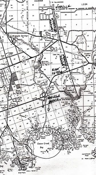
With that in mind, here is a map on how to get to Wakulla Beach. Take the Truck Route south from Apalachee Parkway to Woodville Highway, left on Woodville Highway to Highway 98, and right on 98. After you cross over the Wakulla River on Highway 98 at Lower Bridge (where TnT is located), it will be about 1.3 miles to the Wakulla Beach Road (on the left). Then about 3.5 miles down the dirt road to the end, and you're there. Hope to see you all in the morning.
With that in mind, here is a map on how to get to Wakulla Beach. Take the Truck Route south from Apalachee Parkway to Woodville Highway, left on Woodville Highway to Highway 98, and right on 98. After you cross over the Wakulla River on Highway 98 at Lower Bridge (where TnT is located), it will be about 1.3 miles to the Wakulla Beach Road (on the left). Then about 3.5 miles down the dirt road to the end, and you're there. Hope to see you all in the morning.