Advice on Putting in at Econfina

Moderators: bman, Tom Keels, Chalk
Advice on Putting in at Econfina
My son in law and I generally put in at Keaton Beach but want to try launching at the Econfina. Any free advice? We use an 18 foot bass boat (alum) that drafts about 18 inches of water .. another friend has said that rocks in the river can kill ya. We could use a canoe but then he'd have to paddle me for 2 miles .. plus tend bar, bait my hook, net the fish and pamper me in general. Might tire the poor boy out. Is the river OK at modest tide? It looks like we could lauch Saturday (11th) at the mid point of an outgoing tide and return at midpoint of an incoming.
If there's no soccer (or fishing) in heaven - I'm not going!
-
Jumptrout51
- Site Sponsor
- Posts: 11946
- Joined: December 12th, 2001, 7:00 pm
- Location: Tallahassee


-
Dubble Trubble

- Site Sponsor
- Posts: 2310
- Joined: October 30th, 2005, 7:46 pm
- Location: Thomasville
Here are the spots to look out for. I will warn you, there are also some rocks out in the open water, just go slow until you are in 3 or so feet of water. If you go out with a 1.5 or above, you should be fine. Anything below 1.5, and you are taking chances in my opinion.

Dubble
PS: The markers are tiny and home-made. You will have to look close for them.
Dubble
PS: The markers are tiny and home-made. You will have to look close for them.
The more I know about something, the more I know that I did not know as much as I thought I knew that I knew.

I agree with Tin Can. On your way out you will get to the No Wake Zone around the island. Just as you leave the no wake zone stay to the outside (right side) of the river around that curve. Once you get past that first curve past the no wake zone stay to the middle of the river. As you get to the mouth of the river, stay on plane. It gets really shallow but just a sandy bottom (don't think you'll have any trouble between tides). On low tide you can get stuck outside or inside the river mouth. I have got out and pushed on more than one occassion but no harm done. Just leave me a few fish.
Good Luck !!!!!
Good Luck !!!!!
There is a giant rock about 1.9 miles out!
Cost me $1100 and my boat is in the shop as we speak. Do not go out anywhere near a low tide or try to come back in within 2 hours of a 0 tide. You will not have 18 inches of water.

I think this may have been the post that Chalk was looking for earlier. With Credit to Tom Keels.
Posted: Thu Oct 10, 2002 - 6:25 pm Post subject:
Mapsource is only garmin compatable. I'll post the actual numbers for my route. You need to put them in your respective GPS's as a route. I have tested this route on tides as low as .7 and have no less than 2 feet of water under the boat while on plane the whole route. I do not warranty this against bent skegs or lower units. This is for information only and I will not be responsible for any damages. Use at your own risk.
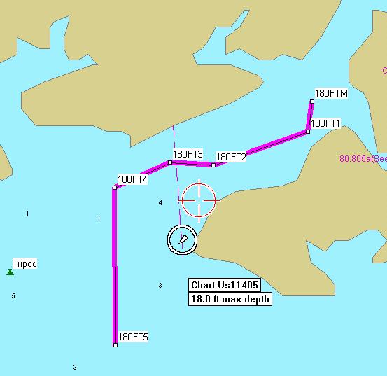
# 180FTM -- N30 02.365 W83 55.286
# 180FT1 -- N30 02.308 W83 55.295
# 180FT2 -- N30 02.246 W83 55.500
# 180FT3 -- N30 02.251 W83 55.594
# 180FT4 -- N30 02.204 W83 55.714
# 180FT5 -- N30 01.908 W83 55.713
Continue on from # 6 along a 180° heading.
_________________
Tom Keels
Owner, Webmaster, Loony Bin Curator
BigBendFishing.Net
The complete thread can be found at...http://www.bigbendfishing.net/phpbb/vie ... ight=route
Posted: Thu Oct 10, 2002 - 6:25 pm Post subject:
Mapsource is only garmin compatable. I'll post the actual numbers for my route. You need to put them in your respective GPS's as a route. I have tested this route on tides as low as .7 and have no less than 2 feet of water under the boat while on plane the whole route. I do not warranty this against bent skegs or lower units. This is for information only and I will not be responsible for any damages. Use at your own risk.
# 180FTM -- N30 02.365 W83 55.286
# 180FT1 -- N30 02.308 W83 55.295
# 180FT2 -- N30 02.246 W83 55.500
# 180FT3 -- N30 02.251 W83 55.594
# 180FT4 -- N30 02.204 W83 55.714
# 180FT5 -- N30 01.908 W83 55.713
Continue on from # 6 along a 180° heading.
_________________
Tom Keels
Owner, Webmaster, Loony Bin Curator
BigBendFishing.Net
The complete thread can be found at...http://www.bigbendfishing.net/phpbb/vie ... ight=route
"Good Judgement" comes from experience, ... and a lot of that..... results from "Bad Judgement".
There's a set of concrete steps on the downriver side of the
two ramps. You need water over the bottom step to launch
and navigate the river. There are some very good pointers in
the above posts. The rock that owns me is about 1 o'clock
from the steps referred to above and 50-60 feet across the
river. I hate that #^!@ rock!
I have been hitting that son of a boulder since 1970.
It may be that my sole purpose in life is simply to serve as a warning to others.

-
Frank Bradfield
- Site Sponsor
- Posts: 535
- Joined: February 26th, 2002, 7:00 pm
- Location: Econfina


