A unique website dedicated to fishing information from Florida's Northern Big Bend. This includes the area from the Econfina River west to the Apalachicola River
I meant to include this information in my report from Saturdays tournament. PLEASE PLEASE put the following location into your GPS if you do not have it already. It's South of Pattys Island.
N 30.03.750
W084.15.333
It's a broken piling/stake and at high tide(on Saturday) it had MAYBE 1 inch out of the water. I was real lucky that it was nearly flat calm or I doubt that I would have seen it. If there were the least bit of chop you'd never know it until you hit it!! I got up close to it to mark it and there had been a piece of pvc pipe attached to it at one time but someone had run over it and broke it off even with the top of the piling. If you happen to be running with just a slight porpoise and came down on it I'm sure you'd end up with a hole!!
"Good Judgement" comes from experience, ... and a lot of that..... results from "Bad Judgement".
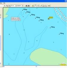
How accurate is that number Bud? This is where it places it on Mapsource...We ran near what looked to be remanants of an old duck blind near that spot the same day....
The yellow speck is the number you gave, the black specks is the stake line that Charles is talking about...
Those stakes run straight as a string across the bay. Except for one. There is one that is out of line and I want to say it's the 5th one out from the west side.
The vicinity of the "Out-of-Line Stake" has been a productive place to fish for decades. I think whoever put the stakes in used that one to mark a fishin' hole.