
Trout Fisher
Be careful next trip out, I bent my skag again
just past the Tripod going out on a very low tide.
Econfina
Moderators: bman, Tom Keels, Chalk
-
trout fisher
- Site Sponsor
- Posts: 489
- Joined: June 19th, 2002, 3:01 pm
- Location: Norman Park, Ga.
Thanks for the heads-up. Did you hang too far to the left? I saw an outboard on a jon boat lift up and flip over into the boat out there year before last. Luckily it was a stick steer and not a tiller. I've gotten to where I'll dang near run over the pvc stob and keep that bearing until I'm a good 1/2 mile out from the mouth before I hang left. That sandbar is growing!!
trout fisher
trout fisher
-
seatrout99

- Site Sponsor
- Posts: 441
- Joined: January 16th, 2002, 7:00 pm
- Location: Climax, GA
- Contact:
-
trout fisher
- Site Sponsor
- Posts: 489
- Joined: June 19th, 2002, 3:01 pm
- Location: Norman Park, Ga.
You've been since I have.  I'm talking about the one inside the river. The one out from the tripod is there off and on. I dunno the story on that.....probably a few disgusted anglers! I stay about 20 ft. to the left of it going out and coming in. The shallowest part of the whole run is from the last curve to just beyond the tripod going out. WATCH OUT this winter if you venture to the flats!!!!! I've had plenty of water in the river and then had to push and tug through that area. I hope the one in the river is still there. I rely on it heavily.
tf
tf
-
seatrout99
- Site Sponsor
- Posts: 441
- Joined: January 16th, 2002, 7:00 pm
- Location: Climax, GA
- Contact:
The one in the river is still there. ( on the right before you get to the tripod, right??) The one on the sand bar out past the tripod is gone, I think. SOmeone, it may have been you, told me to take a heading of 180 degrees after I pass the tripod and stay on that heading at least 3/4 of a mile before I turn in either direction. I marked that route in my GPS last Saturday. It seemed OK at low tide, but I was running a Go-Devil. Didn't seem to bump bottom. I lost all my old points/routes from earlier in the summer when my GPS died in September so I feeling my way around.
Do you go left or right of the tripod going out?
Do you go left or right of the tripod going out?
-
trout fisher
- Site Sponsor
- Posts: 489
- Joined: June 19th, 2002, 3:01 pm
- Location: Norman Park, Ga.
To the right of the tripod.  It's on my left when I go out. You don't wanna go out with the tripod to your right. I see people do it, but their time is coming. There's an oyster bar over there. It gets uglier every year too! The stakes that mark the bar out from the tripod aren't there with any regularity for some reason. I've seen fence posts, candy cane painted stakes, broken boat paddles, pvc, and all other sorts of markers but they are different almost every time I go if they're even there at all. I might have told you that, I don't know. I have it marked in my head. If you hug the stob in the river and go straight out from there about a 1/2 mile you should be o.k. The sandbar is a couple hundred yards out from the tripod and is crooked with what looks to be several offspring sandbars. I haven't been there since Labor Day so I'm guessing it hasn't changed very much. There are quite a few between Rock Island and the mouth as well. I try to stay out the same distance as I started when I'm heading toward R.I. Winter tides will reveal alot to you.
tf
tf
-
Tom Keels
- Site Admin
- Posts: 4044
- Joined: December 11th, 2001, 7:00 pm
- Location: Tallahassee, FL
- Contact:
Tripod to the right going out is how all the guides have taught me. I have a route programmed into my gps that gets me in and out no problem. The trick is you have to take a bearing of 180° from the tripod. If you go straight out from the tripod you will have problems. I will e-mail anyone who has a garmin GPS the route I have.
Tom Keels
Site Founder

Site Founder
-
trout fisher
- Site Sponsor
- Posts: 489
- Joined: June 19th, 2002, 3:01 pm
- Location: Norman Park, Ga.
Tom send it to me. I'm fishing with a buddy on Saturday who has a garmin. We'll try it.......since we'll be in his boat. I've never been out with the tripod to my right side. I started fishing with my daddy down there when I was 7.....when the landing was a dirt, rock makeshift ramp. I've seen people take that route but have always understood it to be taboo. If there's a good path through there it'll take some time off the R.I. run. Thanks.
tf
carltonp@alltel.net
tf
carltonp@alltel.net
-
seatrout99
- Site Sponsor
- Posts: 441
- Joined: January 16th, 2002, 7:00 pm
- Location: Climax, GA
- Contact:
-
Tom Keels
- Site Admin
- Posts: 4044
- Joined: December 11th, 2001, 7:00 pm
- Location: Tallahassee, FL
- Contact:
Mapsource is only garmin compatable. I'll post the actual numbers for my route. You need to put them in your respective GPS's as a route. I have tested this route on tides as low as .7 and have no less than 2 feet of water under the boat while on plane the whole route. I do not warranty this against bent skegs or lower units. This is for information only and I will not be responsible for any damages. Use at your own risk.
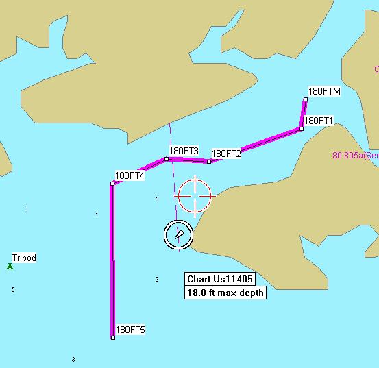
# 180FTM -- N30 02.365 W83 55.286
# 180FT1 -- N30 02.308 W83 55.295
# 180FT2 -- N30 02.246 W83 55.500
# 180FT3 -- N30 02.251 W83 55.594
# 180FT4 -- N30 02.204 W83 55.714
# 180FT5 -- N30 01.908 W83 55.713
Continue on from # 6 along a 180° heading.
# 180FTM -- N30 02.365 W83 55.286
# 180FT1 -- N30 02.308 W83 55.295
# 180FT2 -- N30 02.246 W83 55.500
# 180FT3 -- N30 02.251 W83 55.594
# 180FT4 -- N30 02.204 W83 55.714
# 180FT5 -- N30 01.908 W83 55.713
Continue on from # 6 along a 180° heading.
Tom Keels
Site Founder
Site Founder
-
Jumptrout51
- Site Sponsor
- Posts: 11946
- Joined: December 12th, 2001, 7:00 pm
- Location: Tallahassee
Toms' numbers are really accurate. If your boat is fast enough you can run that route in one foot of water coming or going with no problem. Going out from Toms' last mark ,line up with the first rack and do not slow down until your bottom machine reads 3 feet or more. Otherwise you will still be waiting for more water.
-
trout fisher
- Site Sponsor
- Posts: 489
- Joined: June 19th, 2002, 3:01 pm
- Location: Norman Park, Ga.